Great Himalayan National Park is the latest addition to India’s National Parks System. The area comprising of the watersheds of Jiwa, Sainj, and Tirthan rivers became the Great Himalayan National Park in 1984. It is spread over an area of 1,171 sq kms with altitudes varying from 1500 to 6000m.
We arranged a 5 day trek into GHNP through Raju’s Guest House. They took care of everything including food, tents, hiring porters etc.
Route : Gushaini – Rolla – Chalocha – Nada Thach – Waterfall – Gushaini
Altitudes :
Gushaini 1500m
Rolla 2100m
Chalocha 2450m
Nada Thach 3300m
Waterfall Rolla 2100m
Day 1 : Gushaini (1500 m) to Rolla (2100 m)

Rickety Bridge
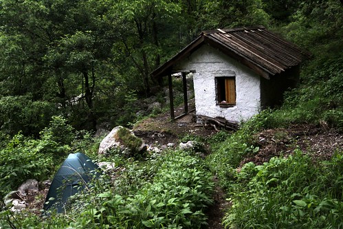
All the villages have been relocated out of the park except for one hut, near Rolla campsite, owned by an elderly man and his wife. They have refused to move and are battling it out in the courts.

Last ‘house’ standing
The GHNP is habitat to more than 375 fauna species including 31 mammals, 181 birds, 3 reptiles, 9 amphibians, 11 annelids, 17 mollusks and 127 insects. The park is a birding paradise. We met a couple of avid birders from Bhopal who were raving about the abundance of birds within the park.

On a wooden ladder bridge?
Camp Rolla

Kitchen Hut and rooms (for porters)

Tirthan river flowing right next to the campsite

Tirthan river
We spotted a Himalayan Goral across the river while filling our water bottles. It is one of the four species in the Nemorhaedus genus, and has a goat-like appearance.

Himalayan Goral (Bottom left above the rocks)

Log stuck between rocks

Tek Singh preparing dinner

Bonfire

Sitting next to the bonfire
Day 2 : Rolla (2100m) to Chalocha (2450m)
Supratim, Sanjay, and Pavel (fellow guests from Raju’s GH) had left for GHNP a day earlier on a 3 day trek (Gushaini – Rolla – Shilt – Gushaini). It was nice to meet them on their way back to Gushaini.

Supratim taking a ‘break’ after the hike down from Shilt

Supratim, Sanjay, and Pavel enjoying their alu parathas
After bidding goodbyes, we proceeded towards Chalocha.

Wooden Bridge towards R-Pai

Ram Lal and Tek Singh leading the way

Looks like Savi is in front of those cheesy backdrops you see in Photo Studios

Finding our way through the rocky terrain

Climbing up the Log Ladder

On a log bridge

Passing under a fallen tree

On a Rickety Bridge

Finally on level ground !

View of the Tirthan
Camp Chalocha

Forest Hut (for cooking and porters’ stay)

Stream next to the campsite – our water source for the next 2 days

“Tree God”
View of the hut and our tent from the “Tree God”

Bonfire

View of the Tirthan from the campsite

Savi, Ram Lal, and Tek Singh
Day 3 : Trek towards Nada Thach (3300 m)
The 5 Km trek up to Nada is a very steep one, gaining about 1000 m in altitude. Someday (hope, hope, hope), I’d like to trek all the way to Tirthan and back.

View of the snow capped mountains

Ferns

Funky looking tree

View from our tent
Day 4 : Chalocha (2450m) to Waterfall (Near Rolla, 2100 m)
We started early so that we could reach the Waterfall before lunchtime. The rains over the past few days had washed away some of the bridges, making certain sections of the trek a tad dangerous.

Waterfall next to the campsite

Campsite
Post lunch, a herd of goats decided to pay us a visit and took over the rock Savi and I were sitting on.

Goats, comfortably parked on our ‘rock’.


Having a bout

Just like ’em boxers

They look cute, but stink like hell!

Platinum blonde, huh?

Campsite

Stream next to the campsite

Wildflowers outside our tent
Unfortunately since this campsite did not have a hut for the porters, they had to sleep under the stars – luckily the weather had cleared up and the sky was clear.

Tek Singh collecting firewood

That’s not a log – that’s a whole tree!
They needed a lot of firewood since they planned to keep the bonfire burning all night long. Two leopards had been spotted in the area three nights ago.

And some more …

Solitary tree

With Tek Singh and Ram Lal (before heading out towards Gushaini)

Hi Jasjit,
Thanks for visiting 10YI.
The cost includes guides, camping gear, and food.
Cheers!
Thanks again. One more question please, how do you get there by road. What is the route you followed? Is there any bus service or did you travel by car?
Thanks for the prompt reply.
Wow !!! Such beautiful pics !! Make me want to make a trip ! 🙂
Excellent photojourney…
reminded me of my Valley of Flowers trip… nothing better than the Himalayas!
Thanks a lot Jitaditya.
Yeah … this is a beautiful trekking route.
We loved it!